Netizen Demonstrates How Train Stations In Malaysia Are Poorly Planned And Inaccessible
"I'm not an urban planner, I'm just a guy who found that it's really tough to get to work."

By May Vin Ang — 10 Nov 2020, 12:52 PM
A netizen living in Klang Valley wrote a Twitter thread that went viral for demonstrating how inaccessible Malaysian train stations truly are
25-year-old Nabil Ersyad took to social media to rant after he realised how frustrating it was to put up with long commute times to get to work, especially with the train systems in Klang Valley.
"I try to take the train whenever I travel and I've always felt that generally, they're pretty inaccessible," he tweeted on Sunday, November 8.
"[The train stations are] usually next to large roads or highways. Pedestrians would find a hard time to get there. So, I decided to do a little research."

In the following tweets, he shared isochrone maps depicting how far a pedestrian would be able to walk from any particular train station
He first used the Sungai Buloh MRT station for example.
"Isochrone maps can show how far you can go from a single point in a given time," he explained. "The green areas will take a person five minutes to walk, yellow 10 minutes, and red 15 minutes."
And he commented that the station's accessibility did not look great, "A five minutes walk will only get you slightly down the road."
"Five minutes covers 0.05kmsq and 15 minutes only covers an area of 0.86kmsq," he added. "If you live in the area anywhere outside like the blue circles I drew, you'll have to walk more than 15 minutes."
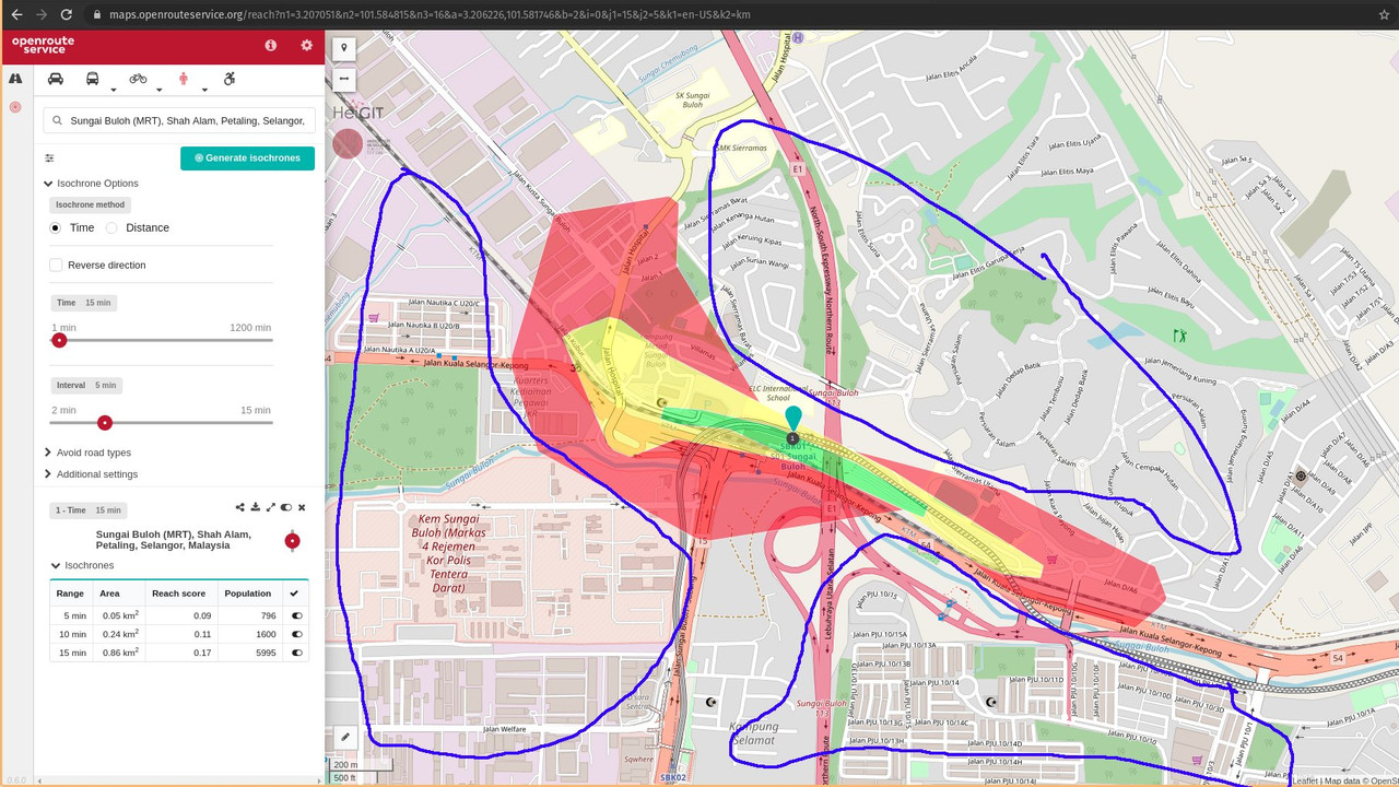
An isochrone map showing the walking coverage of Sungai Buloh MRT station.
Image via @NabilErsyad (Twitter)He then gave a comparison that showed better accessibility to its surrounding areas, which was Pasar Seni MRT station in the middle of Kuala Lumpur.
"It looks a lot more evenly covered. Five minutes [of] walking can get you anywhere within 0.36kmsq area from the station. A 15-minute walk can get you around an area of 3.56kmsq," he said.
He added that this is four times the area covered by the Sungai Buloh MRT station.
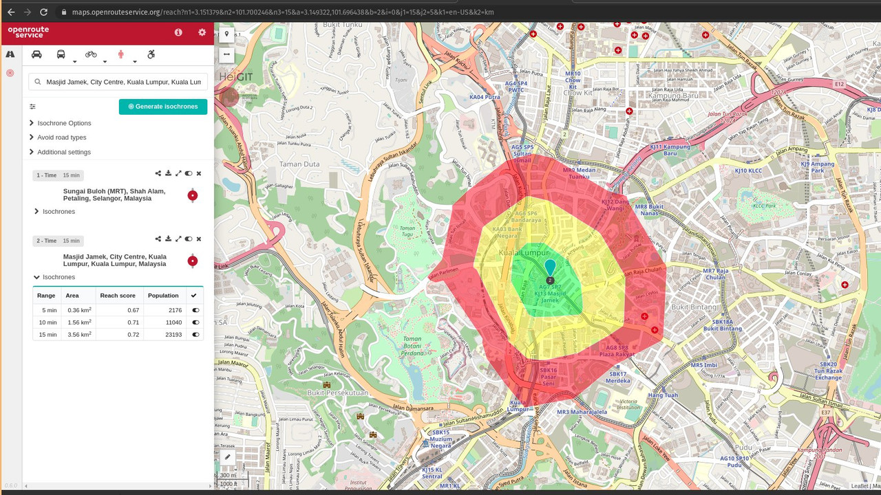
An isochrone map showing the walking coverage of Pasar Seni MRT station.
Image via @NabilErsyad (Twitter)Nabil shared that these are important findings because the average area of walkable distance of train stations in Kuala Lumpur paled in comparison to cities that had better planning and design
"You may ask, what's the big deal. Well, I compiled averages from two other cities that I'm familiar with, Montreal and Singapore. And we're clearly behind," he wrote while sharing bar charts of the different cities.
Meanwhile, he provided more isochrone maps to show how these cities have achieved more with good city planning.
"Note how evenly shaped the isochrones in Montreal and Singapore are. They really maximised the reach of their stations for pedestrians," he said.
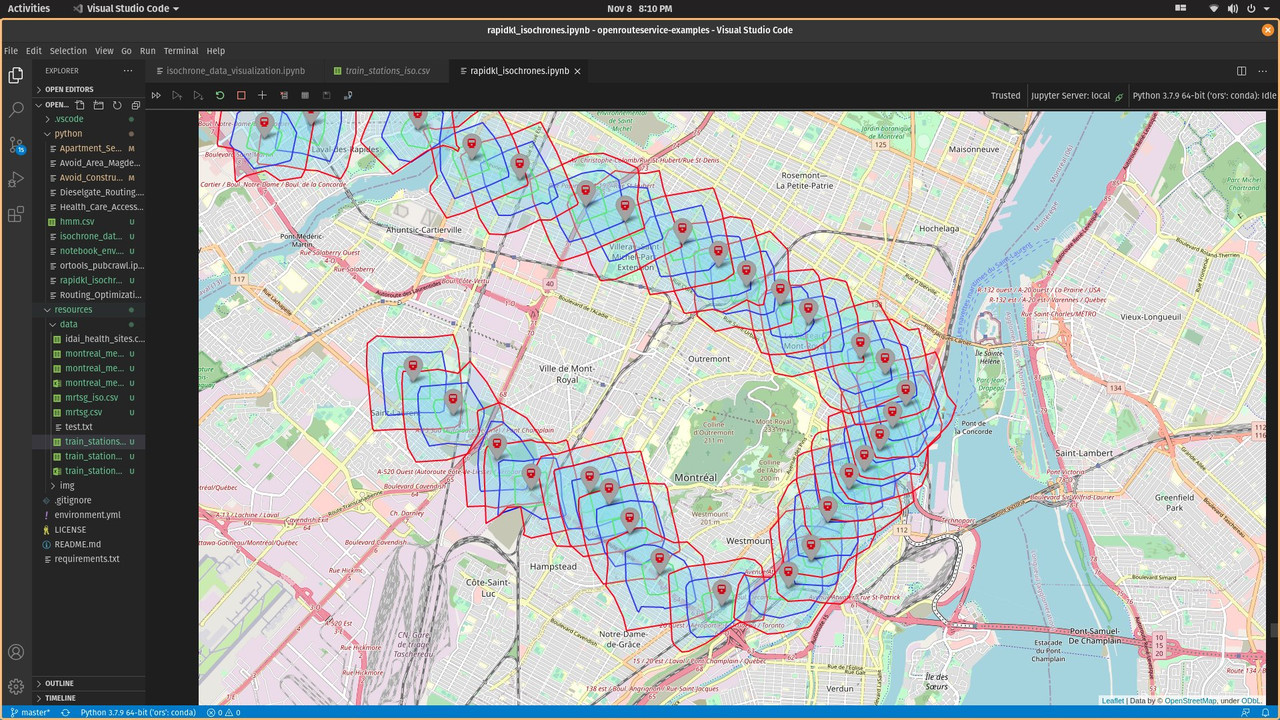
An isochrone map showing the walking coverage of metro stations in Montreal, Canada.
Image via @NabilErsyad (Twitter)"KL has a similar total population with Montreal, but their stations cover a higher population and far more walkable areas," he said.
"Then we have Singapore that is famous for their MRTs. Our climate and culture are similar. So the notion that people don't want to walk because it's hot is not accurate. It's the lack of facility and design."

Isochrone maps showing the walking coverage of train stations in Kuala Lumpur and Singapore.
Image via @NabilErsyad (Twitter)The electrical engineer graduate finally recommended that Malaysia should stop building train stations in the middle of nowhere or next to massive highways
Currently working as a data scientist, Nabil shared with SAYS it is up to the country's city planners to put this information to better use.
"My results just kind of confirmed what I suspected all along. Poor city design followed by poor public transport planning," he said.
"I personally don't know the full solution. I'm not an urban planner, I'm just a guy who found that it's really tough to get to work," he replied when asked if he had solutions to the data he found.
However, he said that he would love to see the cities in Malaysia be more walkable with less cars, less highways, and more affordable housing closer to the city.
"I hope that when they plan more public transport, they'd really study who they are building it for and how to best serve the people," he said.

His Twitter thread garnered over 11,000 retweets as of writing, with netizens praising him for analysing the country's public transport system and giving easy insights and visuals to follow
"Keep doing stuff like this, you're an inspiration! Hopefully someone will take action soon," said a Twitter user.

Another said, "Someone hire this gentleman. You should be a city planner, bro."

Meanwhile, this netizen said, "Nabil here, without any government-level resources, just did a job that the government was supposed to be doing in the first place."